A Geographic Overview of Modern Europe

Political Geography
Europe, one
of Earth’s smallest continents, runs
from Iceland in the Northwestern corner South to the Iberian Peninsula,
bordering Africa and Asia across the Mediterranean Sea east to the Ural
Mountains in Russia and south through Turkey and the Caucuses countries
(Georgia, Armenia, and Azerbaijan), although Europe’s border in the East is
rather artificial and technically it is all part of one huge continental
landmass—Eurasia). On its edges Europe consists of four large peninsulas surrounded by
several large islands. The Scandinavian
Peninsula dominates the North where Norway, Sweden, and Finland are
located; Spain and Portugal are located on the Iberian Peninsula in the
Southwest; moving east from there we encounter first the famed boot of the Italian
Peninsula; and then the Balkan Peninsula with Greece at the southernmost
tip. Along the outside of the European
landmass are several major islands: Iceland, Ireland, the United
Kingdom, and Cyprus south of Turkey.

Physical Geography
The continent is located on a latitudinal parallel
with the Northern United States and Canada, but the warm Gulf stream gives it a
temperate climate, and the soil in most parts is well suited for agriculture—the mainstay of the European economy and society for many
centuries. A series of mountain chains
run across the continent in an East-West direction, reaching their highest
points in the Alps and the Balkans. There
are also a number of important river systems, and the continent’s proximity to
water and sea has clearly been an important factor in its history: the Mediterranean,
which literally means “between the lands,” is one of the most important
waterways in human history because of its vital role as a trade route
connecting various regions of the world,
the Black Sea, Atlantic Ocean, which is particularly crucial to Europe’s
rise to world dominance in the modern period, and North and Baltic Seas, once an avenue of invasion of the
continent’s heartland by Viking Norsemen from Scandinavia. An important aspect of the continent’s physical geography is the lack of natural geographic borders from
the East (the Urals in Russia are very low mountains), making the
continent susceptible to invasion historically from Asia, a crucial factor in
pre-modern European history. Note also the isolation of the British Isles,
which many historians point to as a key reason that country became the most
powerful empire in the world in the colonial period.

Social Geography
While the European continent
is usually spoken of as a whole, there is a great deal of variation across this
large landmass. Firstly, there is the Eastern Europe of the Cold War divide,
running through part of Germany down, excluding Austria but including the
Balkans except for Greece. There is also a significant North-South divide in
Europe. While relative to the rest of the world most of Europe is wealthy
(with the exception of Southeastern Europe, i.e. Albania, the continent’s
poorest and least economically developed country), the poorer European countries tend to be in the South—Spain,
Portugal, and Greece—and especially the East—Poland, Slovakia, the Czech
Republic, Hungary, the Balkans countries, and the rest of the former Soviet
bloc—while Germany, Great Britain,
France, Italy, and the Low Countries (Belgium and the Netherlands) are the
regional economic powers.
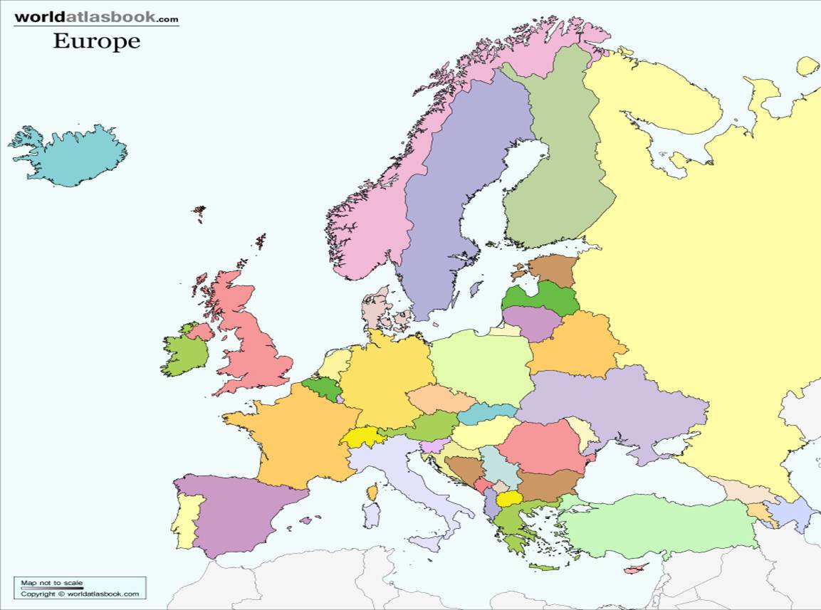
Map Assignment
Practice identifying the
following countries on the blank map above: Sweden; the United Kingdom; Spain; France; Germany; Poland; the Czech
Republic; Italy; Greece; Ukraine; Russia; and Turkey.
MAP QUIZ: Print
out this blank map,
fill out the 12 countries listed above (without looking), put your name on it
and bring it to the next class to turn in.